skip to main content | skip to access keys link
Oxfordshire Wildlife & Landscape Study
  • Joint Character Areas
  • Regional Character Areas
  • Landscape Types
  • Biomap
  • Biolandscape
  • Districts
  • Priority Habitats
Breadcrumb Location > Home > Landscape Types > Chalk Downland & Slopes
contact contact   help help 

Landscape Types:

Chalk Downland & Slopes Introduction

Select a landscape type:
  • Back to Overview Map 
  • Alluvial Lowlands
  • Chalk Downland & Slopes
  • Clay Vale
  • Estate Farmlands
  • Farmland Hills
  • Farmland Plateau
  • Farmland Slopes & Valley Sides
  • Lowland Village Farmlands
  • Pasture Hills
  • River Meadowlands
  • Rolling Clayland
  • Rolling Farmland
  • Rolling Village Pastures
  • Settled Ancient Pastures
  • Terrace Farmland
  • Upstanding Village Farmlands
  • Vale Farmland
  • Wooded Downlands
  • Wooded Estatelands
  • Wooded Estate Slopes & Valley Sides
  • Wooded Farmland
  • Wooded Hills
  • Wooded Pasture Valleys & Slopes
  • Wooded Plateau
View Detailed Information
View Map
Aerial View
Alluvial Lowlands
Chalk Downland & Slopes
Clay Vale
Estate Farmlands
Farmland Hills
Farmland Plateau
Farmland Slopes & Valley Sides
Lowland Village Farmlands
Pasture Hills
River Meadowlands
Chalk Downland & Slopes

2. CHALK DOWNLAND & SLOPES

Regional character areas

North Wessex Downs.

Location

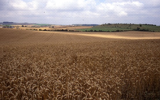
This landscape type covers the downland landscapes across the northern part of the North Wessex Downs.

Overview

An open, downland landscape with steep escarpments and ridges dominated by arable cropping and a number of small plantations.  Remnants of unimproved chalk grassland still survive on some of the steeper slopes.

Key characteristics

Open, undulating landscape with steep escarpments.

  • Large, open arable fields.
  • Variety of woodlands, including recently planted mixed and deciduous plantations, shelterbelts and deciduous secondary and ancient woodland.
  • Extensive areas of chalk grassland and patches of ancient woodland on steep slopes.
  • Sparsely-settled landscape with a few isolated farmhouses.

  • Copyright Oxfordshire County Council 2004
  • www.oxfordshire.gov.uk
  • Access keys
  • Site map
  • Credits