skip to main content | skip to access keys link
Oxfordshire Wildlife & Landscape Study
  • Joint Character Areas
  • Regional Character Areas
  • Landscape Types
  • Biomap
  • Biolandscape
  • Districts
  • Priority Habitats
Breadcrumb Location > Home > Landscape Types > Wooded Farmland
contact contact   help help 

Landscape Types:

Wooded Farmland Introduction

Select a landscape type:
  • Back to Overview Map 
  • Alluvial Lowlands
  • Chalk Downland & Slopes
  • Clay Vale
  • Estate Farmlands
  • Farmland Hills
  • Farmland Plateau
  • Farmland Slopes & Valley Sides
  • Lowland Village Farmlands
  • Pasture Hills
  • River Meadowlands
  • Rolling Clayland
  • Rolling Farmland
  • Rolling Village Pastures
  • Settled Ancient Pastures
  • Terrace Farmland
  • Upstanding Village Farmlands
  • Vale Farmland
  • Wooded Downlands
  • Wooded Estatelands
  • Wooded Estate Slopes & Valley Sides
  • Wooded Farmland
  • Wooded Hills
  • Wooded Pasture Valleys & Slopes
  • Wooded Plateau
View Detailed Information
View Map
Aerial View
Alluvial Lowlands
Chalk Downland & Slopes
Clay Vale
Estate Farmlands
Farmland Hills
Farmland Plateau
Farmland Slopes & Valley Sides
Lowland Village Farmlands
Pasture Hills
River Meadowlands
Wooded Farmland

21.  WOODED FARMLAND

Regional character areas

Cotswolds, Midvale Ridge, Upper Thames Vale and Chilterns.

Location

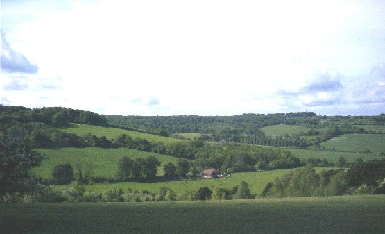
This landscape type is associated with the wooded areas of the Cotswolds Regional Character Area, including Wychwood Forest and the upper Evenlode valley. It also includes the upper part of Boars Hill, the area to the south-east of Otmoor and the dip slope of the Chilterns.

Overview

This landscape type has a distinctively ancient, rural character typified by a mosaic of woodland, enclosed pasture, arable fields as well as scattered farms and settlements.

Key characteristics
  • Large blocks of ancient woodland and a large number of plantations.
  • A varied field pattern of arable land and pasture enclosed by woodland and hedges.
  • Species rich hedgerows with many hedgerow trees.
  • Dispersed settlement pattern with settlements and scattered farms.

  • Copyright Oxfordshire County Council 2004
  • www.oxfordshire.gov.uk
  • Access keys
  • Site map
  • Credits