skip to main content | skip to access keys link
Oxfordshire Wildlife & Landscape Study
  • Joint Character Areas
  • Regional Character Areas
  • Landscape Types
  • Biomap
  • Biolandscape
  • Districts
  • Priority Habitats
Breadcrumb Location > Home > Landscape Types > Rolling Farmland
contact contact   help help 

Landscape Types:

Rolling Farmland Introduction

Select a landscape type:
  • Back to Overview Map 
  • Alluvial Lowlands
  • Chalk Downland & Slopes
  • Clay Vale
  • Estate Farmlands
  • Farmland Hills
  • Farmland Plateau
  • Farmland Slopes & Valley Sides
  • Lowland Village Farmlands
  • Pasture Hills
  • River Meadowlands
  • Rolling Clayland
  • Rolling Farmland
  • Rolling Village Pastures
  • Settled Ancient Pastures
  • Terrace Farmland
  • Upstanding Village Farmlands
  • Vale Farmland
  • Wooded Downlands
  • Wooded Estatelands
  • Wooded Estate Slopes & Valley Sides
  • Wooded Farmland
  • Wooded Hills
  • Wooded Pasture Valleys & Slopes
  • Wooded Plateau
View Detailed Information
View Map
Aerial View
Alluvial Lowlands
Chalk Downland & Slopes
Clay Vale
Estate Farmlands
Farmland Hills
Farmland Plateau
Farmland Slopes & Valley Sides
Lowland Village Farmlands
Pasture Hills
River Meadowlands
Rolling Farmland

12.   ROLLING FARMLAND

Regional character areas

Buckinghamshire Vale, Upper Thames Vale, Midvale Ridge, Vale of White Horse and North Wessex Downs.

Location

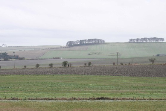
This landscape type is largely associated with the rolling landscapes of the Midvale Ridge, extending from Watchfield and Fernham to Appleton and Dry Sandford. It includes the lower slope of the ridge between Holton and Denton, and, in the Vale of White Horse, the more undulating areas to the east of Didcot. It also covers the rolling landscape at the foot of North Wessex Downs.

Overview

A landscape with a prominent rolling landform and distant views from hillsides across the surrounding low-lying vale. It is associated with large open arable fields and localised blocks of ancient woodland.

Key characteristics
  • Prominent rolling landform.
  • Large, geometric arable fields enclosed by a weak hedgerow pattern.
  • Thinly distributed hedgerow trees.
  • Locally prominent blocks of ancient woodland.
  • Small to medium-sized villages.

  • Copyright Oxfordshire County Council 2004
  • www.oxfordshire.gov.uk
  • Access keys
  • Site map
  • Credits