Landscape Types:
Rolling Farmland
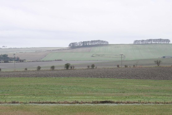
12. ROLLING FARMLAND
Regional Character Areas
Buckinghamshire Vale, Upper Thames Vale, Midvale Ridge, Vale of White Horse, North Wessex Downs.
Location
The landscape type is largely associated with the rolling landscapes of the Midvale Ridge, extending from Watchfield and Fernham to Appleton and Dry Sandford. It includes the lower slope of the ridge between Holton to Denton, and, in the Vale of White Horse, the more undulating areas to the east of Didcot. It also covers the rolling landscape at the foot of North Wessex Downs.
Overview
A landscape with a prominent rolling landform and distant views from hillsides and across the surrounding low-lying vale. It is associated with large open arable fields and localised blocks of ancient woodland.
Key characteristics
• Prominent rolling landform.
• Large, geometric arable fields enclosed by a weak hedgerow pattern.
• Thinly distributed hedgerow trees.
• Locally prominent blocks of ancient woodland.
• Small to medium-sized villages.
Geology and landform
The underlying geology of the Midvale Ridge is a mix of corallian limestone and calcareous sandstone. To the east of Didcot there is a mix of Gault Clay and Upper Greensand, marking the transition between the downs and the lower-lying vale. It is also characterised by free-drained soils associated with the corallian beds and chalk at the foot of North Wessex Downs. The northern parts of the landscape are underlain by Upper Lias Clay. Outcrops of limestone and sandstone give rise to a smooth, rolling landform which, in parts, is dissected by minor valleys emphasising its undulating nature.
Land use and vegetation
This is a very intensively managed landscape dominated by arable cropping and some improved grassland. Semi-improved pasture occurs locally in areas around Dry Sandford and Holton, and there is some unimproved calcareous grassland on the steeper hillsides at the foot of North Wessex Downs, with Blewburton Hill being a good example. Another characteristic feature which is locally prominent on some of the steeper slopes is the medium to large-sized blocks of ancient woodland. In some areas there are scattered small to medium-sized deciduous plantations. In the very intensively cultivated areas within the Vale of White Horse, tree cover is largely confined to small tree clumps surrounding farmhouses.
In certain areas there are small streams and ditches lined by trees, strips of semi-natural woodland and pasture. They offer some intimacy in an otherwise open, intensively managed landscape. Good examples are Sandford and Pennyhooks Brooks, the ditches around Holton, the streams at Fernham, Appleton and parts of the North Wessex Downs.
Cultural pattern
The field pattern is weak and dominated by large rectangular arable fields. Those fields which are managed as semi-improved grassland tend to be smaller. They are enclosed by low, species-poor hedges consisting mainly of hawthorn, blackthorn and elm. In some cases there is a scattering ash, oak and dead elm, particularly where hedges have been removed. In places the hedges are taller, thicker and support more trees, particularly along roadsides and adjacent to semi-improved grassland. Overall, the views are open, distant and on the higher ground there is a distinctive expansive character to the landscape. In other areas the landscape is much more enclosed and views are either filtered through hedgerow trees or framed by the rolling landform, high roadside hedges and woods.
The settlement pattern is characterised by small to medium-sized villages. Originally, many of these would have been nucleated in shape but, as a result of more recent expansion, they have become linear and sprawling, particularly at Appleton and Wootton. The settlement pattern is also characterised by small hamlets and sparsely scattered farmhouses. The density of housing is higher along parts of the Midvale Ridge, especially between Buckland and Eaton and around Dry Sandford. In a few of the smaller villages, such as Eaton, Buckland, Mackney and Fernham, and in the centre of some others, including Great Coxwell, Shrivenham and Denton, the vernacular character of the buildings is strong. It is quite prominent in most of the villages at the foot of North Wessex Downs, where the nucleated character of the settlements is also better preserved. These particular villages were originally located at the foot of the Downs to take advantage of the springlines emerging at the junction of the chalk and clay. The choice of building materials varies throughout the landscape type. Within the Midvale Ridge there is limestone, or limestone with bricks framing the windows, and thatched roofs or clay tiles. In the Vale of White Horse and North Wessex Downs it is mainly red bricks and clay tiles whereas the older houses are often bricks and timber frames with thatched roofs. In villages at the foot of the Downs some of the houses are built of clunch, a hard type of chalk.
BIODIVERSITY
Overview
This rolling farmland landscape is dominated by large-scale arable farming, but still supports a relatively wide range of locally important and priority habitats.
Key Characteristics
• Bioscores are predominantly low-medium to medium, although in certain areas this rises to medium-high to high.
• Priority habitats include species-rich hedges, neutral and wet grassland, fen , reedswamp and species-rich watercourses.
General Description
This relatively large landscape type occupies around 5.6% of the rural county. Although it is dominated by intensive arable farming, it still supports a range of locally important habitats including deciduous woodland, plantations, semi-improved grassland, scrub, species-poor hedges with trees and tree-lined watercourses. Ancient semi-natural woodland and parkland are other important habitats to be found. A number of priority habitats have been recorded including calcareous, neutral and wet grassland, reedswamp, fen and species-rich watercourses. The Midvale Ridge is notable for many of these priority habitats, and the area around Cothill is particularly important in this respect as it includes sites of international importance such as Cothill Fen.
LOCAL CHARACTER AREAS
A. Godington Hall (BC/2)
Landscape character
Medium-sized arable fields dominate the landscape and there is some semi-improved grassland. Fields are enclosed by low, well-managed hawthorn and blackthorn hedges. There are scattered oak, ash and willow trees and small copses surrounding farmhouses. There are also a number of scattered small deciduous woodlands dominated by oak and ash, as well as some mixed plantations and a medium-sized block of ancient woodland.
Biodiversity
Bioscore/Bioband: 31/LM
This area supports a limited range of locally important habitats including deciduous woodland and plantation, semi-improved grassland, scrub, and species-poor hedges with trees. There are no recorded priority habitats, but there is some ancient semi-natural woodland.
Landscape character
The area is characterised by a mixture of small-sized arable fields and some semi-improved grassland. They are enclosed by intact hawthorn hedges with ash trees. A dense corridor of hawthorn and ash fringes the Oxford canal. Woodland cover is limited to a poplar plantation and some hawthorn and ash scrub alongside the railway.
Biodiversity
Bioscore/bioband: 33/LM
This area supports a range of locally important habitats including plantation, scrub, semi-improved grassland, canal, and species-poor hedges with trees. There were no recorded priority habitats.
Landscape character
This area is dominated by large, rectangular arable fields. There are some smaller fields consisting of wet grassland bordering Pennyhooks Brook. Fields are generally enclosed by hawthorn and blackthorn hedges, and tree cover is limited to mature oak and sycamore in the hedges and a few scattered tree clumps. On some slopes there are surviving blocks of small to medium-sized ancient semi-natural woodland. Most of the field boundaries are low, and many internal field boundaries have either been removed or replaced by fences, thus creating an open landscape with distant views over to the Vale of White Horse.
Biodiversity
Bioscore/Bioband: 81/M
There are a number of locally important habitats including plantations, semi-improved grassland, species-poor hedges with trees and tree-lined watercourses. Within the area are a few scattered blocks of ancient semi-natural woodland to the east of Watchfield and adjacent to the county boundary south of Coleshill Park. Recorded priority habitats include some wet grassland and fen adjacent to Pennyhooks Brook and some calcareous grassland and fen at Tuckmill Meadows. Both these relatively small and isolated sites are found along the Pennyhooks Brook valley.
Landscape character
This area is characterised by medium-sized, regularly-shaped arable and improved grassland fields. They are enclosed by reasonably intact hawthorn and elm hedges, and in some of these there are mature oak and ash trees. Tree cover is consists mainly of small blocks of deciduous and ancient semi-natural woodland, and a watercourse lined by ash and willow is a locally prominent feature.
Biodiversity
Bioscore/bioband: 52/LM
This area supports a range of locally important habitats including deciduous woodland, semi-improved grassland, scrub, species-poor hedges with trees and tree-lined watercourses. No priority habitats were recorded, although there is some ancient semi-natural woodland north of the village.
Landscape character
The area is dominated by large, geometric arable fields and some large fields of improved grassland. They are enclosed by hawthorn and elm hedges. Towards the north, where the land slopes steeply into the Upper Thames Vale, some of the fields with semi-improved grassland are bounded by small blocks of ancient woodland and overgrown hedges. Hedgerow trees of oak, ash and dead elm are thinly scattered throughout the area, and where hedges have been removed they are the only structural elements remaining in the landscape. They are denser along parish boundaries. Discrete large blocks of ancient woodland, such as Pusey Common Woodland and Appleton Upper Common, are locally prominent. Significant parts of these woods have been planted with conifers. Occasionally, small deciduous and mixed plantations add structure to an otherwise open landscape. There is also a dense corridor of willows and some oak bordering the stream at the eastern boundary of the area. The field pattern is generally in a poor condition, with hedges frequently low, fragmented and in many places removed altogether. This results in a large-scale, open landscape with views which are confined locally by the large woods and rolling landform.
Biodiversity
Bioscore/bioband: 74/M
This area has a range of locally important habitats including plantations, semi-improved grassland, species-poor hedges with trees and tree-lined watercourses. There are several significant blocks of ancient semi-natural woodland including Appleton Upper Common, which is around 50 ha and in favourable condition and management. There is also a small area of neutral grassland, which falls partially within the landscape type near Cumnor.
Landscape character
The area has large open arable fields to the west of Sandford Brook and smaller fields of semi-improved grassland to the east. The arable fields are enclosed by a fragmented pattern of low hawthorn and elm hedges with few hedgerow trees, resulting in an open landscape. Where grassland dominates, the hedges are often tall, thick and species-rich, with shrubs such as dogwood, spindle, wild privet and field maple, particularly along roadsides. Hedgerow trees are also more prominent in this area, and wet secondary woodland and calcareous fen next to Sandford Brook are a notable feature. To the south, the landscape is dominated by Abingdon airfield. There is a small patch of acid grassland at the edge of the airfield, and part of it is enclosed by species-rich hedges that include spindle, dogwood and wild privet.
Biodiversity
Bioscore/bioband: 149/H
Although this area only supports a limited range of locally important habitats including semi-improved grassland, species-poor hedges with trees and tree-lined watercourses, it is particularly notable for its priority habitats. These include the calcareous fen, species-rich watercourses and ponds associated with Cothill Fen and Dry Sandford Pit, some of which are of international significance. There are also areas of wet woodland, some ancient semi-natural woodland and species-rich hedgerows with trees. A narrow strip of acid grassland survives along the road verge to the north of Abingdon airfield.
Landscape character
Medium-sized arable fields dominate this area, but there is some semi-improved grassland and pony paddocks on the slopes. Fields are generally enclosed by relatively intact low hawthorn hedges, and there is also a large block of ancient woodland on the slope.
Biodiversity
Bioscore/bioband: 57/LM
There is only a limited range of locally important habitats including semi-improved grassland and species-poor hedges. The main features of interest are Brasenose Wood, which is a large block of ancient semi-natural woodland, and a small patch of neutral grassland.
Landscape character
The landscape is dominated by medium to large-sized arable fields, particularly on the slopes around Denton and to the south of Cuddesdon. Around Holton there are some smaller fields of semi-improved grassland. Throughout the area the pattern of hedgerows and hedgerow trees adds coherence to the landscape. Hedgerow trees include oak, sycamore, willow and poplar. Around Holton there are more mature trees and the density is higher. This area is also more wooded in appearance. Holton Wood is a large block of ancient semi-natural woodland and there are a number of smaller deciduous plantations, mainly poplar or willow, and trees bordering watercourses. The hedges are generally low, gappy, and sometimes, in places such as Cuddesdon and Denton, removed altogether.
Biodiversity
Bioscore/bioband: 66/M
The area supports locally important habitats such as deciduous plantations, semi-improved grassland, scrub, species-poor hedges with trees and tree-lined watercourses. Part of Holton Wood falls within the area and is a large block of ancient semi-natural woodland. Adjacent to the wood there is some neutral grassland.
I. Brightwell-cum-Sotwell (WH/9)
Landscape character
This is a landscape of medium to large-sized arable and grass fields. They are enclosed by hawthorn, blackthorn and elm hedges with some oak and ash trees. Towards the north, where it slopes down to the River Thames and Little Wittenham, it has a more wooded appearance. There are small to medium-sized plantations, a semi-natural oak and ash woodland and a large block of ancient woodland. Most of the internal field hedges are fragmented, whereas the roadside hedges are intact, tall and thick. Views are framed by the woodlands and tall hedges.
Biodiversity
Bioscore/bioband: 42/LM
A number of locally important habitats were recorded including plantations, deciduous woodland, semi-improved grassland, and species-poor hedges with trees. There were no priority habitats, but Little Wittenham Wood, at just under 70 ha, is a significant block of ancient semi-natural woodland on the slope to the south of the River Thames.
Landscape character
The hill is dominated by large-sized arable fields. It is an open landscape with few hedges. Tree cover is largely confined to small ornamental plantations surrounding farmhouses. At the foot of the hill there are reed-fringed ditches lined with poplars.
Biodiversity
Bioscore/bioband: 33/LM
There are a few locally important habitats including species-poor hedges and tree-lined species-rich watercourses at the foot of the hill.
Landscape character
Large-sized arable fields dominate the landscape. Hedges have been largely removed throughout most of the area resulting in an open, large-scale landscape. Tree cover is limited to distinctive groups of trees around farmhouses and farm buildings. There is a block of ancient semi-natural woodland, which stands out in this otherwise treeless landscape.
Biodiversity
Bioscore/bioband: 35/LM
There is a limited range of habitats including deciduous woodland, plantations and some species-poor hedges with trees. There is also a linear strip of ancient semi-natural woodland to the west of Cholsey.
Landscape character
The landscape is dominated by large-sized arable fields. There are a few surviving areas of unimproved and semi-improved grassland. Fields are enclosed by hawthorn and elm hedges with sparsely scattered ash and elm trees. Hedges are generally fragmented except where they border tracks. Throughout the area there are a number of different sized deciduous and mixed linear plantations. Many of the watercourses are lined by willow, ash, poplar and linear strips of semi-natural woodland. These add to the tree cover and create locally intimate landscapes.
Biodiversity
Bioscore/bioband: 96/MH
This area supports a range of locally important habitats including deciduous woodland, plantations, semi-improved grassland, scrub, species-poor hedges with trees and tree-lined watercourses. Priority habitats include small areas of calcareous grassland, less than 5 ha, on Blewburton and Lollingdon Hills. There are also tree-lined species-rich springlines draining off the chalk, including Ginge Brook and Letcombe Cress Beds.
FORCES FOR CHANGE
• Intensive arable farming has resulted in the large-scale fragmentation and removal of hedges, particularly internal field boundaries. The remaining hedges tend to be low and intensively maintained.
• There is some impact from residential development in the villages. It consists mainly of moderate to large-scale new housing development, which is not always in keeping in with the traditional character of the villages. In places, there is extensive ribbon development.
• Some large agricultural buildings and barns are visually prominent, out of scale, poorly located and using inappropriate materials.
• Overhead power lines around Moulsford and Horspath are visually intrusive in this open landscape.
• Abingdon airfield, with its associated depots and large-scale housing, has had a visual impact on the open rural landscape.
• Harwell laboratories, which cover a large area, is a very dominant feature and out of character with the surrounding open, farmed landscape of the North Wessex Downs.
Landscape strategy
Conserve and enhance the surviving pattern of woodlands, hedgerows, hedgerow trees and tree-lined watercourses. Minimise the impact of built development through appropriate location, choice of building materials, and the use of locally characteristic tree and shrub species.
Guidelines
Landscape Character
• Strengthen the field pattern by planting up gappy hedges using locally characteristic species such as hawthorn, and hedgerow trees such as oak and ash.
• Promote environmentally-sensitive maintenance of hedgerows, including coppicing and layering when necessary, to maintain a height and width appropriate to the landscape type.
• Enhance and strengthen the character of tree-lined watercourses by planting willows and ash and where appropriate, pollarding willows.
• Promote the sustainable management of existing ancient semi-natural woodland to safeguard its long-term survival.
• Promote small-scale planting of deciduous woodland blocks using locally characteristic species such as oak and ash.
• Conserve the surviving areas of permanent pasture and promote arable reversion to grassland, particularly on land adjacent to watercourses.
• Minimise the visual impact of intrusive land uses with the judicious planting of tree and shrub species characteristic of the area. This will help to screen the development and integrate it more successfully with its surrounding countryside.
• Maintain the nucleated pattern of settlements and promote the use of building materials and a scale of development and that is appropriate to this landscape type. This includes limestone or limestone and bricks and clay roof tiles in the Midvale Ridge, and red bricks and clay tiles in the Vale of White Horse and North Wessex Downs.
Biodiversity Strategy
Ensure that all surviving priority habitats are safeguarded, in favourable condition and management, and enhanced to satisfy the actions and targets identified within the relevant habitat and species action plans. Safeguard, maintain and enhance all locally important habitats in a way which is appropriate to the landscape character of the area. Promote agri-environment schemes which will benefit biodiversity in general and protected species and farmland birds in particular.
Guidelines
• Most of the unimproved calcareous grassland within the landscape type has a statutory or non-statutory wildlife designation. The priority must be to ensure that all these sites are in favourable condition and management. With S.S.S.I.s this can be achieved, where appropriate, through formal agreement between the landowner and English Nature. For county wildlife sites this can be promoted with advice from organisations such as the Farming and Wildlife Advisory Group, and the targeting of agri-environment schemes. The aim should be to establish a balance between species-rich calcareous grassland and scrub. Opportunities for extending and linking this type of priority habitat are fairly limited as many of the existing sites are small and isolated. Opportunities for expanding this habitat include the establishment and management of field margins/buffer strips adjacent to existing calcareous grassland habitat using native wildflower species appropriate to the area.
• Cothill Fen, Dry Sandford Pit and Tuckmill Meadows support calcareous fen and species-rich watercourses and ponds. The former has been designated as a Special Area of Conservation and the last two are S.S.S.I.s and nature reserves owned and managed by the local wildlife trust. The priority is to ensure that they remain in favourable condition and management through formal agreement between the landowners and English Nature. Opportunities for successfully expanding this habitat type throughout the landscape type are limited, although it may be feasible to make improvements to the water catchment areas centred on Sandford and Pennyhooks Brooks to maintain and extend this rare calcareous fen habitat.
• Ancient semi-natural woodland is a significant feature throughout the landscape type. The priority must be to ensure that all these sites are in favourable condition and management, particularly those which have been designated S.S.S.I.s or county wildlife sites. Opportunities for linking these sites would be difficult because of their isolation, but it may be feasible to expand their size through woodland grant schemes using appropriate tree and shrub species.
• Species-rich hedgerows are distributed throughout different parts of the landscape type. Priority should be given to safeguarding, maintaining and expanding this resource using appropriate tree and shrub species, particularly in those local character areas where they remain a significant feature.
• Tree-lined watercourses are a feature throughout the landscape type. They should be safeguarded and enhanced by planting species such as ash and willows, pollarding willows where appropriate, and establishing buffer strips/field margins to potentially benefit small mammals, invertebrates and birds.
• Opportunities for the establishment of other locally important habitats, such as semi-improved grassland and small deciduous woodlands, should be promoted in order to strengthen wildlife corridors and enhance the local landscape character.
• Promote the use of agri-environment schemes such as conservation headlands, overwintered stubbles, and winter-sown crops to benefit farmland birds such as skylarks and yellowhammers.
Key Recommendations
• Safeguard and enhance landscape character of the surviving hedgerow network, ancient semi-natural woodlands, species-rich hedgerows and tree-lined watercourses.
• Ensure that all priority habitats are in favourable condition and management and seek opportunities for extending and linking these habitats whenever appropriate and practicable.