skip to main content | skip to access keys link
Oxfordshire Wildlife & Landscape Study
  • Joint Character Areas
  • Regional Character Areas
  • Landscape Types
  • Biomap
  • Biolandscape
  • Districts
  • Priority Habitats
Breadcrumb Location > Home > Landscape Types > Farmland Plateau
contact contact   help help 

Landscape Types:

Farmland Plateau Introduction

Select a landscape type:
  • Back to Overview Map 
  • Alluvial Lowlands
  • Chalk Downland & Slopes
  • Clay Vale
  • Estate Farmlands
  • Farmland Hills
  • Farmland Plateau
  • Farmland Slopes & Valley Sides
  • Lowland Village Farmlands
  • Pasture Hills
  • River Meadowlands
  • Rolling Clayland
  • Rolling Farmland
  • Rolling Village Pastures
  • Settled Ancient Pastures
  • Terrace Farmland
  • Upstanding Village Farmlands
  • Vale Farmland
  • Wooded Downlands
  • Wooded Estatelands
  • Wooded Estate Slopes & Valley Sides
  • Wooded Farmland
  • Wooded Hills
  • Wooded Pasture Valleys & Slopes
  • Wooded Plateau
View Detailed Information
View Map
Aerial View
Alluvial Lowlands
Chalk Downland & Slopes
Clay Vale
Estate Farmlands
Farmland Hills
Farmland Plateau
Farmland Slopes & Valley Sides
Lowland Village Farmlands
Pasture Hills
River Meadowlands
Farmland Plateau

6.   FARMLAND PLATEAU

Regional character areas

Cotswolds and Northamptonshire Uplands.

Location

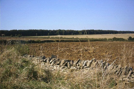
This landscape type covers the plateau across the elevated northern part of the county. It extends across the areas between Chipping Norton and Banbury and is dissected by the rivers Evenlode, Glyme and Dorn. To the east of the Cherwell Valley the plateau continues northeast of Upper Heyford and Fritwell. The most southern part lies to the northwest of the River Windrush.

Overview

This landscape type is characterised by a high limestone plateau with a distinctive elevated and exposed character, broad skies and long distance views. Large scale arable fields dominate the landscape, with some medium-sized plantations partially obscuring the otherwise open views.

Key characteristics
  • Level or gently rolling open ridges dissected by narrow valleys and broader vales.
  • Large, regular arable fields enclosed by low thorn hedges and limestone walls.
  • Rectilinear plantations and shelterbelts.
  • Sparsely settled landscape with a few nucleated settlements.
  • Long, straight roads running along the ridge summits.

  • Copyright Oxfordshire County Council 2004
  • www.oxfordshire.gov.uk
  • Access keys
  • Site map
  • Credits