Landscape Types:
Chalk Downland & Slopes
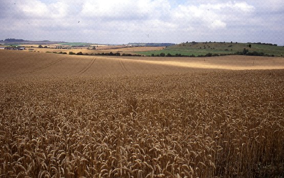
2. CHALK DOWNLAND & SLOPES
Regional Character Areas
North Wessex Downs.
Location
This landscape type covers the Downland landscapes across the northern part of the North Wessex Downs.
Overview
An open, downland landscape with steep escarpments and ridges dominated by arable cropping and a number of small plantations. Remnants of unimproved chalk grassland still survive on some of the steeper slopes.
Key Characteristics
• Open, undulating landscape with steep escarpments.
• Large, open arable fields.
• Variety of woodlands, including recently planted mixed and deciduous plantations, shelterbelts and deciduous secondary and ancient woodland.
• Extensive areas of chalk grassland and patches of ancient woodland on steep slopes.
• Sparsely settled landscape with a few isolated farmhouses.
Geology and landform
The geology of the area includes the layers of the Lower, Middle and Upper Chalk. The Middle and Upper Chalks give rise to smoothly rolling downland resulting in a series of rounded hills and ridgelines. Along the northern edge of the landscape type, the eroded surface of the Lower Chalk gives rise to the prominent steep escarpment. The scarp dominates the skyline and forms a dramatic backdrop to the adjacent low-lying clay vale. In some areas it is almost vertical, and in places such as White Horse Hill it becomes dramatically convoluted.
Land use and vegetation
This is an intensively farmed landscape with arable farming as the predominant land use. Significant areas of grazed chalk grassland are a prominent feature on the north-facing escarpment where cultivation is more difficult. Unimproved grassland can also be found on the steeper slopes at Tower Hill to the west, and at West Ginge and Knollend Downs to the east. Grassland is also a characteristic feature of the large number of horse gallops throughout the landscape type. Linear mixed and deciduous plantations, shelterbelts and round beech clumps are scattered throughout. They are locally prominent features which contain distant views and give a sense of enclosure to an otherwise open landscape. Larger blocks of woodland are found at the western end as semi-natural woodland in Ashdown Park, and at the eastern end as mixed plantation woodland at Betterton and Wether Downs. Occasional, small to medium-sized blocks of ancient woodland occupy the north-facing escarpment and slopes at Upper Black Bushes.
Cultural pattern
This is a large-scale, open landscape where field boundaries have largely been removed, thus emphasizing the strong, characteristic landform. Where they survive, they create a pattern of large regular fields bounded mainly by hawthorn hedges and by wire fences on the steeper slopes around Weathercock Hill. Hedgerow trees are generally very sparse. Several green lanes and tracks, including the Ridgeway, are also enclosed by tall hawthorn hedges and include other species such as purging buckthorn. The geometric field structure is accentuated by rectilinear plantations and a network of straight roads which cut across the escarpment.
This is a planned landscape derived from extensive areas of open sheep-grazed downland that were enclosed during the 18th and 19th centuries. The planned character is typified by very large, straight-sided fields, plantations and roads. Another characteristic feature of this planned landscape is that it is very sparsely settled with isolated and widely dispersed farms. Vernacular building materials include red bricks and clay tile roofs.
A number of internationally important prehistoric monuments are found within this landscape type, including the famous White Horse, the Ridgeway, an Iron Age hill fort and Bronze Age barrows. Medieval strip lynchets delineate the slopes of the escarpment. Some of the best surviving examples of unimproved chalk grassland are associated with these archaeological features.
BIODIVERSITY
Overview
An open downland landscape with steep escarpments, dominated by large arable fields and a very fragmented pattern of hedgerows. Significant areas of unimproved chalk grassland and small blocks of ancient woodland still survive.
Key Characteristics
• Bioscores range from low to medium.
• Priority habitats are calcareous grassland and semi-natural ancient woodland.
General Description
This is a comparatively large landscape type occupying just over 4% of the rural county. Its locally important habitats include deciduous woodland, different types of plantation, semi-improved grassland and species-poor hedges. Most of the deciduous woodlands are relatively small and isolated, with the largest being Middle Hailey Woods near Ashdown House. The only recorded priority habitats are unimproved calcareous grassland and some ancient semi-natural woodland. The largest areas of calcareous grassland, at around 75 ha, are of national importance and include White Horse Hill and Hackpen, Warren and Gramp’s Hill Downs. Others are around 20 ha and there are a number of relatively small sites around 2 ha. Most of them tend to be relatively isolated, confined to steep slopes and sometimes in unfavourable management and condition. The ancient woodlands are also scattered throughout and are generally around 4-5 ha in size.
LOCAL CHARACTER AREAS
A. North Wessex Downs Escarpment (WD/1)
Landscape Character
This area is characterised by the very visible and distinctive north-facing escarpment of the North Wessex Downs. Large, open arable fields dominate but the area is also dotted with numerous small to medium-sized mixed and deciduous plantations and the occasional small block of ancient woodland. There are significant remnants of unimproved chalk grassland at places such as White Horse Hill.
Biodiversity
Bioscore/Bioband: 74 /M
There are the usual locally important habitats including woodlands, plantations, semi-improved grassland, scrub and species-poor hedges. However, the area is notable for surviving areas of unimproved chalk grassland including some that is of national and/or international importance. The best examples are White Horse Hill and Hackpen, Warren and Gramp’s Hill Downs. These are relatively large sites around 75 ha but others vary from around 20 ha at Kingston Combes to small sites such as Odstone Hill Lane at less than 2 ha. Their condition and management vary and a number of the smaller, more isolated sites are beginning to be invaded by scrub through lack of grazing. There is also some ancient semi-natural woodland including Uffington Wood, which is an ash-hazel hangar with a rich ground flora next to White Horse Hill.
B. Lambourn Downs (WD/2, WD/5, WD/8)
Landscape Character
A downland landscape with large, open arable fields, where the pattern of hawthorn hedges is either fragmented or lost. There is a range of different woodlands, including linear and mixed, and deciduous plantations. Beech plantations are often characteristically small and round. Occasionally, medium-sized blocks of ancient woodland can be found at places such as Upper Black Bushes. The larger blocks of deciduous woodland are confined to the western end of the landscape type as semi-natural woodland in and around Ashdown Park, and at the eastern end as mixed plantations at Betterton and Wether Downs. Surviving patches of chalk grassland, frequently associated with Bronze Age barrows, can be found at Woolstone Down and around West Ginge and Knollend Downs.
Biodiversity
Bioscores/Biobands: 31/LM: 71/M: 49/LM:
Apart from a small number of locally important habitats including deciduous woodland, beech and mixed plantations, semi-improved grassland and species-poor hedges, there are several relatively small patches of unimproved grassland on the steeper slopes at West Ginge and Knollend Downs. The calcareous grassland sites are generally around 5-8 ha in size. They are largely confined to steeper slopes and are generally isolated and sometimes in unfavourable condition and management. The ancient woodland sites are close to the county boundary south of Wantage, and include Black Bushes Wood.
Landscape Character
A prominent, steep-sided ridge with areas of chalk grassland on the lower slopes. Arable land enclosed by wire fences is more localised and found mainly on the higher, more level parts of the ridge. Woodland cover is insignificant, and limited to a linear shelterbelt and a small beech plantation.
Biodiversity
Bioscore/bioband: 29/L
Apart from some plantations, surviving patches of chalk grassland found along the lower, steep-sided slopes of Kingstone Down constitute the main feature of interest. This is a relatively large expanse of species-rich grassland at 24 ha and it is in reasonable condition and management.
Landscape Character
A gently rolling, large scale and intensively farmed arable landscape. The total absence of any woodland features creates a very open character. There are only a few trees around farm buildings and very fragmented hawthorn hedges along tracks and roads.
Biodiversity
Bioscore/Bioband: 7/L
This area is almost totally devoid of semi-natural habitats. It is mainly large arable fields and scattered hawthorn hedges, mainly bordering tracks and roads. There are no priority habitats.
FORCES FOR CHANGE
• Agricultural intensification has historically led to the loss of field boundaries and chalk grassland. Where chalk grassland still survives there may be a continuing deterioration in its quality through a lack of sustainable grazing.
• Where field boundaries still survive, particularly along tracks and roads, they are very fragmented and gappy.
• Apart from occasional barns, there is no significant impact from built development.
• Tall structures, such as overhead pylons and communication masts are locally visually intrusive in this open downland landscape.
• A significant part of this landscape type falls within part of the North Wessex Downs Area of Outstanding Natural Beauty. A Management Plan and Landscape Character Assessment for the A.O.N.B. will provide detailed strategies and guidelines which will potentially benefit both landscape character and biodiversity.
Landscape Strategy
Conserve overall pattern of open downland and beech plantations and encourage arable reversion to grassland particularly along the escarpment and in association with features of archaeological importance.
Guidelines
• Promote the restoration and expansion of chalk grassland by extending and linking existing sites. Restoration of chalk grassland along the escarpment, particularly in association with sites of archaeological importance and where it is visually prominent, would enhance both its landscape and wildlife value.
• Restore the structure of existing hedgerows, particularly those bordering greenlanes and tracks by planting up gaps, using species such as hawthorn and purging buckthorn, and coppicing and layering where appropriate.
• Promote limited planting of small deciduous woodland copses, using species such as beech, in locations and to a scale appropriate for this landscape type.
• Avoid, as far as it is practicable, locating visually intrusive structures in areas where they are highly visible.
• Protect and conserve all archaeological features, particularly those which support areas of species-rich chalk grassland.
• Maintain the sparse settlement pattern and remote character of clear skylines and ridges.
Biodiversity Strategy
Ensure that all surviving priority habitats are safeguarded, in favourable condition and management, and enhanced to satisfy the actions and targets identified within the relevant habitat action plans. Safeguard, maintain and enhance locally important habitats in a way which is appropriate to the landscape character of the area. Promote agri-environment schemes which will benefit biodiversity in general and protected species and farmland birds in particular.
Guidelines
• The main priority habitat within this landscape type is the surviving species-rich chalk grassland. Most of it has a statutory or non-statutory wildlife designation. The priority must be to ensure that all these sites are in favourable condition and management through the promotion and implementation of sustainable grazing regimes, management agreements with landowners and the targeting of agri-environment schemes. Opportunities for expanding and linking the existing chalk grassland resource to meet habitat action plan targets should also be actively promoted through the use of agri-environment schemes, particularly along the escarpment and in association with features of archaeological and historic importance.
• There is only a very limited amount of ancient semi-natural woodland and the priority should be to protect this habitat and ensure that it is in favourable condition and management.
• Other locally important habitats, such as deciduous woodlands, plantations and hedgerows, add to the overall biodiversity interest. The aim should be to ensure that they are in favourable condition and management, without necessarily seeking to expand this resource in a way which is detrimental to the landscape character of the area.
• Promote the use of agri-environment schemes, such as conservation headlands, to benefit farmland birds such as skylark.
Key recommendation
A priority must be the conservation and sympathetic management of the existing areas of species-rich chalk grassland. Opportunities for linking and expanding this resource should be promoted through the targeting of agri-environment schemes, particularly in those areas such as the escarpment, to benefit both landscape character and biodiversity.