| skip to main content | skip to access keys link
Oxfordshire Wildlife & Landscape Study
  • Joint Character Areas
  • Regional Character Areas
  • Landscape Types
  • Biomap
  • Biolandscape
  • Districts
  • Priority Habitats
Breadcrumb Location > Home > Districts > Districts - Parishes > Vale of White Horse
contact contact   help 

Districts:

Vale of White Horse Parishes

Select District:
  • Districts - Parishes
    • Cherwell
    • South Oxfordshire
    • Vale of White Horse
    • West Oxfordshire
  • Districts - Landscape Types
Vale of White Horse Parishes
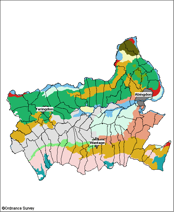
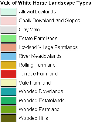
This map highlights the landscape types within the parish you selected, and its associated local character areas. You can click on any area of the map for a description of its landscape character and biodiversity. Please note that local character areas can cover large areas of the countryside, and may include several parishes, so the description may not be specific to this parish. If there are any wildlife habitats within the parish their descriptions can be found by scrolling to the bottom of this page.

Vale of White Horse Parishes Image Map

Clay Vale B Prescote Little Coxwell North Hinksey North Hinksey Appleford-on-Thames Lyford South Hinksey Besselsleigh Besselsleigh Besselsleigh Besselsleigh Goosey Goosey Hatford Fernham Denchworth Pusey West Challow Garford Garford Frilford Charney Bassett Charney Bassett Sunningwell Kennington West Hanney West Hanney West Hanney West Hanney Bourton Bourton Bourton Bourton Bourton Bourton Bourton Upton Chilton Milton Watchfield Watchfield Watchfield Wootton Eaton Hastings Baulking East Challow Letcombe Bassett Great Coxwell Shellingford Shellingford Wytham Wytham Wytham Compton Beauchamp St. Helen Without St. Helen Without St. Helen Without St. Helen Without St. Helen Without Longcot Woolstone West Hendred West Hendred West Hendred Hinton Waldrist Coleshill Kingston Lisle Sutton Courtenay Appleton-with-Eaton Appleton-with-Eaton Appleton-with-Eaton Appleton-with-Eaton Appleton-with-Eaton Appleton-with-Eaton Appleton-with-Eaton Kingston Bagpuize with Southmoor East Hanney Letcombe Regis Abingdon Longworth Littleworth Steventon Steventon Grove Harwell Marcham Shrivenham Shrivenham Shrivenham Radley Drayton Drayton Ardington Ardington Ardington Fyfield and Tubney Wantage Buscot Stanford in the Vale Stanford in the Vale Uffington Childrey East Hendred East Hendred East Hendred Sparsholt Great Faringdon Great Faringdon Lockinge Blewbury Buckland Ashbury Cumnor Cumnor Cumnor

Legend


  • Copyright Oxfordshire County Council 2004
  • www.oxfordshire.gov.uk
  • Access keys
  • Site map
  • Credits