Landscape Types:
Rolling Village Pastures
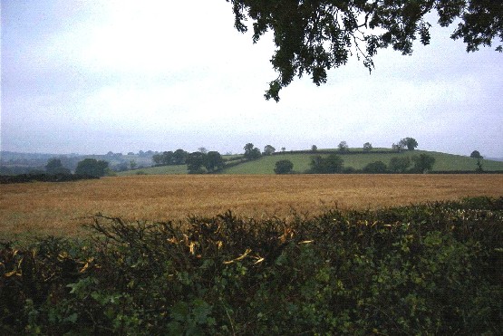
13. ROLLING VILLAGE PASTURES
Regional Character Areas
Northamptonshire Uplands, Cotswolds.
Location
This landscape type covers the rolling pastoral landscapes in the north of the county around Swalcliffe, Hook Norton and South Newington.
Overview
The landscape type is characterised by a distinctive landform of small rounded hills and narrow valleys. Unspoilt ironstone villages, with a strong vernacular character, form part of the tranquil countryside.
Key Characteristics
• A strongly undulating landform of rounded hills and small valleys.
• Small to medium-sized fields with mixed land uses, but predominantly pasture.
• Densely scattered hedgerow trees.
• Well-defined nucleated villages with little dispersal into the wider countryside.
Geology and landform
The geology of this area is quite complex, giving rise to a distinctive landform. The Middle Lias series, which consists of sands and clays, is exposed in this part of the county. It is overlain by the Marlstone Rock Bed, which is an iron-bearing limestone. The outcrop of the Middle Lias is broken by fault lines. From Hook Norton, these run in an east-west direction through Wigginton, South Newington and the Barfords. Faulting has also uplifted an area of Northampton Sand and White Limestone, of the Inferior and Great Oolite Groups respectively, around Tadmarton and the Sibfords.
As a result of the faults and the numerous small streams cutting through the landscape, the landform is shaped into steeply-sided, convoluted valleys with narrow valley bottoms surrounded by rolling, rounded hills. The steep slopes in the south form part of the Swere valley. The underlying geology gives rise to clay soils with a high iron content and a characteristic reddish-brown colour. Sandy soils occur in the vicinity of Tadmarton, Wigginton and Sibford Heaths although there is very little acid grassland and heathland habitat still surviving.
Land use and vegetation
Land uses are generally linked to the pattern of hills and valleys. The hill tops and gentler slopes are mainly in arable cultivation, whereas semi-improved and rough grassland interspersed by scrubby vegetation and gorse dominate the steeper hillsides. Pony grazing is also evident throughout the area. A characteristic feature is the medieval ridge and furrow pattern on the slopes, which is often clearly visible from a distance.
Small copses and mixed plantations of oak, ash, larch and Scots Pine are characteristic features on the hilltops and slopes. Crack willows, along with linear stretches of secondary woodland and scrub, border the streams and valley bottoms. Wet pasture lies adjacent to some watercourses.
Cultural pattern
The fields are generally medium-sized and regular in shape, but they are smaller and more irregular when associated with grazing land. Hedges are generally tall and dominated by hawthorn and blackthorn with occasional elm. Those surrounding arable land are more intensively maintained. Although there are no large woodlands, the dense mature hedgerow trees of oak and ash, particularly those bordering roads, create filtered views and give the impression of a well-wooded landscape.
The settlement pattern consists of small, well-defined nucleated villages and dispersed farmsteads. Hook Norton is the largest settlement. The vernacular character is strong in most villages, particularly in Epwell, Swalcliffe, Sibford Ferris, and Sibford Gower. The distinctive ironstone, used as a building material, gives rise to the characteristic warm reddish-brown buildings with stone or slate roof tiles. Sunken lanes connect villages and are a characteristic feature of this landscape type.
BIODIVERSITY
Overview
Much of the main biodiversity interest, where it survives, is associated with the steeper valley sides and valley bottoms. Semi-improved grassland and patches of scrub are typical of the former, whereas marshy and neutral grassland is more characteristic of the latter.
Key Characteristics
• Low-medium to medium-high bioscores/biobands.
• Priority habitats include calcareous, neutral and marshy grassland.
General Description
This landscape type occupies around 1.7% of the rural county. It supports a range of locally important habitats including deciduous woodland, plantations, species-poor hedges with trees, semi-improved grassland and tree-lined watercourses along the valley bottoms. Broughton Park, with its associated mature trees, lake and semi-improved grassland, includes a number of locally important habitats. Priority habitats such as calcareous, neutral and marshy grassland still survive in localised areas including parts of the Swere valley. Calcareous grassland and scrub associated with parts of the disused railway at Hook Norton is also of interest. There are also patches of acid grassland found alongside gorse scrub on some of the steeper valley sides.
LOCAL CHARACTER AREAS
A. Sibford Gower (CW/39)
Landscape Character
The area has medium-sized fields with mainly semi-improved grassland and some arable cropping. The pasture is mainly used for pony grazing and dairy stock. On steeper slopes, the grassland is interspersed with scattered gorse. Fields are enclosed by a weak pattern of tall hawthorn hedges, many of which have been replaced by fences or removed altogether, particularly where arable farming is dominant. Mature hedgerow trees, consisting mainly of ash, sycamore and some oak, are prominent throughout the area. They are sparser within field hedges and where arable farming dominates. There are a few mixed plantations with species such as ash, oak and Scots Pine.
Biodiversity
Bioscore/bioband: 31/LM
This area supports only a limited range of locally important habitats including plantations, semi-improved grassland and species-poor hedges with trees. There are no recorded priority habitats, but gorse scrub is a notable feature.
Landscape Character
The area has a regular pattern of large arable fields to the east and smaller, semi-improved grass fields to the west including some ridge and furrow. There are a number of oak and ash hedgerow trees and a watercourse fringed by willows, some of them pollarded. A number of small woods are located on the hilltops, steep slopes and valley bottom.
Biodiversity
Bioscore/bioband: 63/M
This area supports a slightly wider range of locally important habitats. As well as the usual plantations, semi-improved grassland and species-poor hedges, there are tree-lined watercourses, wet woodland and ponds. Some acid grassland and gorse scrub can be found on some of the steeper slopes.
Landscape Character
The area has a medium-scale, regular pattern of predominantly arable and semi-improved grass fields, some of which are used for pony grazing. Arable farming, mainly associated with the gentle rounded hills and grassland often mixed with scrub, is found on the lower valley slopes. Wet woodland, scrub and rough grassland are also characteristic of the valley bottoms. Hedges consist mainly of hawthorn, blackthorn and elm, and they tend to be in better condition along roadsides where there are also prominent hedgerow trees with species such as oak, ash and beech. There are a few hilltop mixed plantations.
Biodiversity
Bioscore/bioband: 76/M
Apart from the usual locally important habitats such as plantations, semi-improved grassland and species-poor hedges, there are other important habitats associated with Broughton Park including its species-rich lake and mature trees. There are also examples of wet woodland and wet, species-poor grassland and tree-lined watercourses.
Landscape Character
The area has a mixed pattern of farming, with both arable and grassland. Fields are small, regularly-shaped and enclosed by a prominent network of tall hawthorn and blackthorn hedges. The hedges tend to be much lower where arable farming is dominant. There are a number of ash and oak hedgerow trees, particularly where there is pasture, as well as a few small ash and willow plantations.
Biodiversity
Bioscore/bioband: 49/LM
This area supports locally important habitats such as plantations, semi-improved grassland bounded by species-poor hedges with trees. Its only priority habitat is a patch of surviving calcareous grassland.
E. Hook Norton (Southrop) (NU10)
Landscape Character
This area has a regular pattern of small to medium-sized fields which are mainly semi-improved pasture, some used as pony paddocks, and some arable land, particularly around Milcombe. Hedges are generally tall and in good condition, but are often much lower where arable farming dominates. On the minor valley slopes there are patches of rough grassland, a little bit of unimproved calcareous grassland mixed with scrub and blocks of semi-natural woodland with species such as ash, oak and field maple.
Biodiversity
Bioscore/bioband: 116/MH
This part of the landscape type tends to score more highly because it supports a range of priority habitats including calcareous, neutral and marshy grassland found within parts of the Swere valley to the east of Hook Norton. Further along the same valley there is also some neutral grassland close to South Newington. Calcareous grassland can still found along parts of the disused railway at Hook Norton. There is also quite a wide range of locally important habitats including plantations, semi-improved grassland, species-poor hedges with trees, scrub and tree-lined watercourses.
Landscape Character
The area is characterised by medium-sized fields with arable farming on the gentler slopes to the southwest of Barford St. Michael. There is some unimproved calcareous grassland and ridge and furrow is common and very prominent on the hill slopes. The hedges are generally tall, well-maintained and in good condition and those surrounding arable fields are lower and with fewer trees.
There are many hedgerow trees, consisting mainly of ash, oak and willow, as well as ash and willow bordering some ditches along the valley bottoms. A few small poplar and mixed plantations add to the tree cover.
Biodiversity
Bioscore/bioband: 73/M
Locally important habitats include plantations, semi-improved grassland, species-poor hedges with trees, scrub and tree-lined watercourses. Other important habitats include parkland and its associated features such as mature trees and lakes. The only recorded priority habitat is some surviving calcareous grassland near South Newington.
FORCES FOR CHANGE
• On the steeper slopes, where there is less arable cultivation, there remains an intact pattern of dense, thick hedges particularly bordering roads. However, where there is more intensively managed arable land the hedges tend to be low and gappy and the hedgerow trees much sparser. To the north of the landscape type many hedges have been removed and been replaced by fences.
• Development in the villages is mostly small scale, usually in character and contained within the existing settlement pattern. Minor exceptions to this can be found on the edge of Hook Norton and around Milcombe.
• All the stone quarries in the area have been restored back to agriculture although some of the associated conifer screen planting can be visually intrusive.
Landscape Strategy
Conserve the unspoilt character of the ironstone villages and surrounding countryside. Conserve and enhance the pattern of hedgerows, hedgerow trees and tree-lined watercourses.
Guidelines
• Strengthen the field pattern by planting up existing gappy hedges and replacing fences using locally characteristic species such as hawthorn and hedgerow trees such as oak and ash.
• Promote environmentally-sensitive maintenance of hedgerows, including coppicing and layering when necessary, to maintain a height and width appropriate to the landscape type.
• Conserve the surviving areas of permanent pasture, particularly remnants of ridge and furrow pasture and promote arable reversion to grassland, particularly along the valley sides and bottoms.
• Contain the size of settlements and promote the use of building materials and a scale of development and that are appropriate to this landscape type.
• Promote small-scale planting of deciduous woodland blocks using locally characteristic species such as oak, ash and field maple.
• Enhance and strengthen the character of tree-lined watercourses by planting willows and ash, and where appropriate pollarding willows.
Biodiversity Strategy
Ensure that all surviving priority habitats are safeguarded, in favourable condition and management, and enhanced to satisfy the actions and targets identified within the relevant habitat and species action plans. Safeguard, maintain and enhance all locally important habitats in a way that is appropriate to the landscape character of the area.
Guidelines
• There is a range of priority habitats, including calcareous, neutral and marshy grassland, but these are largely associated with localised sites within parts of the Swere valley. There are also surviving patches of acid grassland and gorse on some of the steeper slopes.
• A number of these areas have been designated as county wildlife sites, which need to be safeguarded and the priority is to ensure that they are in favourable condition and management through suitable grazing and fertiliser regimes agreed with the landowner.
• Along the disused railway embankment at Hook Norton establish a balance between species-rich limestone grassland and scrub. Prevent scrub encroachment in areas of species-rich grassland. Opportunities for expanding this habitat include the establishment and management of field margins/buffer strips adjacent to existing limestone grassland habitat using native wildflower species appropriate to the area.
• Parklands, including Broughton Park with its associated habitats of woodlands, trees, lakes and semi-improved grassland, make a significant contribution to the biodiversity resource of the landscape type and their structural and species diversity should be safeguarded and maintained.
• Tree-lined watercourses are a feature throughout the landscape type. They should be safeguarded and enhanced by planting species such as ash and willows, pollarding willows where appropriate.
• Opportunities for the maintenance and establishment of other locally important habitats, such as semi-improved grassland, wet grassland and small deciduous woodlands, should be promoted in order to strengthen wildlife corridors, particularly along the valley bottoms, and enhance the local landscape character.
Key Recommendations
• Safeguard and enhance the landscape character of the hedgerow network, small woodlands and tree-lined watercourses.
• Ensure that all priority habitats are in favourable condition and management.